The Bumpsteads, Haverhill and Castle Camps
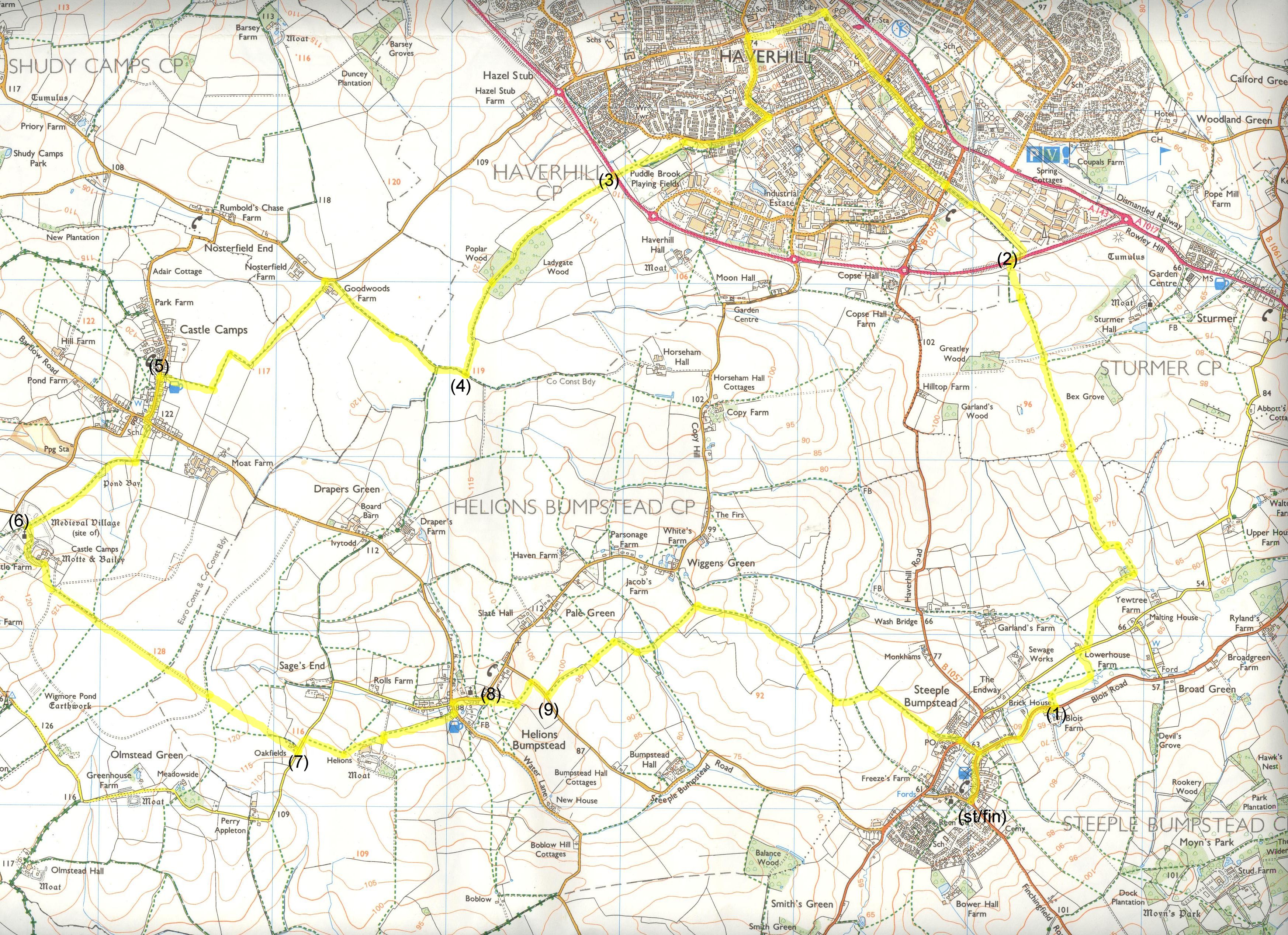
Description: A pleasant walk, partly in Essex, partly in Suffolk, under huge skies at times thanks to the pretty flat terrain. Firstly Haverhill, then the remote church and former castle, at Castle Camps are visited, before the return leg of the walk goes through the attractive village of Helions Bumpstead. The figures in brackets correspond to markings on the map, also co-ordinates from my Garmin eTrex (see bottom of page for file!)
OS Ref: TL680410
Length: 12½ Miles approx.
Approximate time: 4½-5¼ hours.
Parking: Road-side parking in Church Street, Steeple Bumpstead.
Refreshments: Pubs at Steeple Bumpstead. Pubs or restaurants in Haverhill. Pub in Helions Bumpstead.
Black-spots:
1 - The path on the OS map should go diagonally across a field from TL685417 to TL687419 just north of Blois Road. The current implementation of this seems to go along the southern, then eastern end of this field. During the crop growing season, it can be treacherous between TL687418 and TL686419. There should theoretically be a cross-field route here, but it's not been implemented for a while.
2 - An area between TL687419 and TL689423, which is pretty hard to navigate normally, can be made a lot harder during crop growing, as the paths can be totally overgrown. I can offer no alternative here - just use your instinct if the crops are chest-high, to get to TL689423! There seem no decent alternatives east of this, else I would alter the route.
3 - The path going NNW from TL687427 to the boundary at TL686431 can be a bit treacherous during crop growing. Also the power-line poles after this, mentioned in the main text can't be seen for some while.
4 - The area between Ladygate Wood and Poplar Wood can be very muddy - it's possible to walk to the side (off the "beaten track") to get over the worst of this. On exiting Poplar Wood (between TL652440 and TL651435), navigation can be hampered during crop growing. There's no real alternative here, unless you use roads some distance from the walk route.
The walk
Start between the Fox and Hounds pub and Moot Hall, at the end of Church Street. Moot Hall dates back to 1592. There are a number of similarly named places in Britain. In this context, a moot hall is meeting or assembly building, traditionally to decide local issues.
Turn left to walk along Chapel Street, in the direction of Haverhill (B1057). After a while, the road bends left. At this point, carry on in an ENE direction along Blois Road. Ignore the first public footpath signpost to the left, but take the next one (1). Cross a stile, cross a field then cross another stile, then turn right to cross a metal bridge, before turning right to follow a stream in an ENE direction. At the corner of the field, just before a bridge, turn left then follow the path to a road. Turn right along the road and walk about 50 metres to come to Lower House Farm on the left. Take a track on a ramp just after the house, and at a footpath signpost turn left.
Follow the left edge of a field for a while then leave it to go in the direction of a way-marker on the far side of the field (don't be tempted by the one on the far left corner of the field). Go right at it, then follow the path along the left edge of a field. There are some white-tipped posts along this path for a while, mainly on the other side of a ditch, but they're not any sort of navigation aids! Just after a small wooded area on the left, turn left at a way-marker. At another way-marker, turn slightly right to follow the left edge of a field. When the field to the left ends, go slightly right, aiming for the left of five trees on the far side.
Pass just to the right of it (heeding the arrow on it) to cross a bridge. Notice a couple of poles bearing a power-line in the distance. Keep on in the same direction, then a double-pole power-line support appears on the horizon to the left of these. Keep focused on, and aim for the latter, because they're a point of reference for quite some distance. Haverhill soon appears on the horizon. Keep on to cross a plank bridge, going slightly up-hill after it, coming to our focal point for the last few hundred metres! Pass to the left of the poles and turn slightly left to continue to a gap. Go through the gap, going down some steps shortly after to a road. Cross the road and make for a signpost the other side. Go up some steps, then down the other side of the embankment to a way-marker (2). At present, this is a building site, and the original footpath route has been diverted slightly. Anyway, follow the way-marker right, soon to go left at another one. Carry on to the corner of this plot, then cross a stile to continue in the same direction, eventually coming to a road (Bumpstead Road).
Cross the road to follow a signpost on the other side (just slightly right of where we came out). Keep on this path to come to a concrete bollard on the right, near a way-mark post. Turn right here and continue to Croft Lane, just after a right bend. Carry on to the end of Croft Lane, turning left at Hamlet Road. We're going to pass a couple of Haverhill's jewels along this road. Firstly Anne of Cleves House on the left, then the "Old Independent" United Reformed Church on the right. Anne of Cleves House is a magnificent Tudor building, said to have been given by Henry VIII to his fourth wife as part of a divorce settlement.
At the White Hart public house, carry on into High Street, then continue to the parish church on the left. Just after the church, turn left into Camps Road. Continue, eventually coming to a park on the left. At the far corner of the park, turn left at Clements Lane. Follow Clements Lane for about 450 metres, and then turn right into Greenfields way. Continue along the road, ahead at a mini roundabout to a zebra crossing. At the crossing, there is a footpath signpost pointing half-left. Follow it across a recreation area, going through a narrower part, then past a football pitch. Aim for a gate, soon visible in a WSW direction. Go through this (metal) kissing gate.
Cross a road to carry on in the same direction the other side (3), firstly staying on the left edge of a field. After a short while, when we lose the hedge to the left, we'll have to aim for the right side of a wood (Ladygate Wood) in the distance. On coming to the corner of the wood, follow a way-marker to skirt the right side of it, before going left then right to enter it (more accurately between Ladygate Wood and Poplar Wood). It can be very muddy here, as this seems a popular venue for off-road motor-cycling! On exiting the wood(s), follow a path on the left edge of a field, soon to go slightly left then right. Carry on to a tee junction of paths. There are no actual navigation aids here in the form of way-markers or signposts, but it's pretty obvious when you get to it.
Turn right at the tee junction (4) and keep a ditch to your left, walking roughly in a north-westerly direction. After 800 metres or so you come to some farm buildings by a road. Turn left onto the road for a brief spell (about 20 metres). Follow a signpost pointing left, to walk along a track to the right of the farm buildings. Cross a stile; carry on with a ditch to your right. Cross another stile, then immediately turn right then left to be on the right side of the ditch. Follow the left edge of two fields, turning right at the far corner of the second. Turn left after another 120 metres or so, then walk to a gate, with a kissing gate to its right. Go through the kissing gate and turn right, following the path for approximately 300 metres before going through a kissing gate to come to a road (High Street) in Castle Camps.
Turn left (5) along the road to a tee junction. Turn left (along Park Lane,) then immediately right to follow a small signpost (on the opposite side of the road). Cross a field then turn right at a marker on one of the fence posts in front of you. After coming to a copse on the left, turn slightly left to walk along the right (north-west) edge of it, soon coming to a bridge. Cross the bridge then walk along the boundary between two fields, the remote church of All Saints visible ahead. Go through a fairly old metal kissing gate to follow the left edge of a meadow, then through another (rather rickety) wooden kissing gate in the far left corner of the meadow.
Turn left (6) at a lane to pass the east end of the church. Go through a gate. Follow the lane round to the right first then left, ignoring the first signpost you see, to walk around the grounds of a former castle, with a brick wall to the left. The Castle probably originated as a Saxon Fortress. There is also evidence that the area was attacked by Danish invaders in the 10th Century. Nearby Roman roads and burial grounds show that invaders came here in even earlier times. Anyway, after the wall finishes, look out for a signpost directing you to go through a new metal kissing gate. Walk diagonally in a SSE direction across a field to another new metal kissing gate in the far right corner. Start along a concrete path in a SE direction for about 1100 metres (¾ mile). Towards the end of this stretch, you can see both the villages of Helions Bumpstead and Steeple Bumpstead just to the left of ahead. When the path ends at a tee junction, keep in the same direction you have been going, to pass to the left of some jumping fences for horses. This path follows a somewhat different route to the ones on the map (which I originally tried) but seems quite legitimate. Believe me - you could end up pretty muddy if you follow the documented paths, as I did first time I attempted the walk!
Where a hedge begins, go to the right of it to walk on the left edge of a field to pass a way-marker at the end. Keep ahead on an enclosed path, with a wood fence to the right initially. On coming to a road, turn left (7) for a short while, coming to a signpost on the right. Follow a route in the direction pointed to by the signpost (almost doubling back on yourself). Very shortly, look out for a boundary between two fields to the left. Take this and turn left at the end. At a way-marker go half-right to follow the right side of a field in the direction of Helions Bumpstead. The path leaves the side of the field near its far end. At a track, by a way-marker, keep ahead to cross a plank bridge the other side of the track, to walk along the left edge of a field. At a way-marker by a gap, turn left to follow a path to a road, emerging just next to the Three Horseshoes pub.
Go left onto the road (Water Lane) for a short distance, then turn right at Church Hill. The well-kept church is worth a visit. Some parts of the building date back to the 14th century, with additions made in the 15th and 16th centuries. Pass to the right of the church then, at a left bend in the road where it meets Mill Road, follow one of a pair of signposts, pointing left (8), to go in an easterly direction. Walk to the right of a building to a playing field. Turn left after the building to walk to the left of a football pitch. Carry on to a way-marker by a gap in the hedge, to go left through it. Follow the path to a road, turn right then walk along the road to a signpost directing you left (9).
Walk along the left edge of a field to cross a plank bridge at the corner. Carry on across the next field in the direction of a pole ahead, bearing a power-line. Pass the pole then turn right at a way-marker. Follow the path to the corner of the field, then cross a plank bridge to walk straight ahead in an easterly direction. Bear left at another way-marker to walk along the right edge of a field. After losing the hedge on the right, keep on in the same direction to reach a gap ahead. Go through it then turn right. After following the right edge of a field for about 300 metres, go right-left where a track joins from the left, to go through a gap to be on the left edge of the adjacent field. Keep on for about another 300 metres to go right at a way-marker (not quite sure if it's really necessary, but it might stop you ending up in a ditch if it's pitch black!)
At another way-marker, go through a gap to go across a field. Cross a plank bridge on the other side, turn right for a few strides, then left at a way-marker. Keep ahead at another way-marker to follow the left edge of the field, turning right at its far corner. Keep on for about 400 metres, going through a gap by another way-marker, to turn right. Keep ahead at the second corner to walk to the right of some allotments. This can be a very muddy experience if there's been a recent spell of rain (I've nearly ended up in a non-vertical position here without the aid of any alcohol!) On reaching a road on the outskirts of Steeple Bumpstead, cross it then walk ahead along Claywell Bridge. Cross a bridge over a tributary of the River Stour, and then turn right into Chapel Street. Retrace your steps to the start by Moot Hall.
Click here to get an OS map with the route highlighted.
Click here for a file containing Garmin eTrex details for the walk.
The etrex information can be uploaded to a Garmin unit from the Garmin Mapsource program. You'll need a serial cable with the dedicated Garmin plug at the "appliance end". These can be bought at a reasonable price on ebay! I guess however, that the more recent units use a USB cable with a mini-usb connection at the appliance end?
The waypoints were directly obtained from each location, so accuracy should be within 15-20 feet.
|
|