Goodnestone, Chillenden and its mill from Wingham
OS Ref: TR244576
Length: 7¾ miles
Approximate time: 2½ 2¾ hours
Parking: Free car park in St. Mary's Meadow, Wingham
Refreshments: Pubs in Wingham, Chillenden and Staple
The walk
Start by exiting the car park, turning left onto St. Marys Meadow. Turn left at the High Street, continuing in the same direction where the main road goes right, to walk in the direction of Aylsham and Folkestone. Carry on until you come to Staple Road on the left turn left here, then soon-after right, to follow a signpost in the direction of Goodnestone and Chillenden.
For a short distance you can seek the refuge of the recreation ground, by going through an entrance to the right. Walk on the left edge of the ground, rejoining the road by going through another gap BEFORE some tennis courts. After a short while, take the footpath on the right, which runs parallel to the road. Walk along the right edge of three fields, heading left at the end of the third, to go through a kissing gate. Head along the right edge of another field, which normally has a collection of animals on it. There can sometimes be a very territorial dog here you have been warned!
On coming to a road, turn left along it for a short while, then right to walk along the right edge of a field (001). Continue along this long field, turning left at its far corner, then right at a waymarker to enter a wooded area. On exiting the wood, turn half-right, to follow a path heading towards the right side of another wooded area, after crossing a track. Bear left to keep the trees directly to your left. After a while, leave the edge to carry on in the same direction, heading just to the right of Goodnestone church tower, which is now visible.
Turn half-left further on (002), to follow a gravel track, which soon crosses another track, eventually coming into the little village of Goodnestone. If you want to make a small detour here, you could turn right on the road to go to the famous Park Gardens. The church is also worth a visit, some parts of it dating back to Saxon times.
If you visited any of the attractions at Goodnestone, make your way back to the footpath then turn right... If you didn't however venture off-track, carry on the other side of the road (in a ESE direction). At a waymarker, follow the right path of two, coming to a wood (there is an information board here which makes interesting reading).
Cross a stile to walk through Long Wood, crossing a track after some while carry on to a road. Cross the road to follow a path in the same direction the other side, towards a lone tree. Chillenden Mill soon comes into view on the left. After the initial field, the progress can be a bit slower, especially if there are potatoes being grown! This stretch ends up in a meadow the path here can be a bit vague, but your goal is a kissing gate just slightly off to the left (003).
Descend the path to a road, turning left onto it (if you want to visit Chillenden, you could clamber up the path the other side of the road it's only a short way). Anyway, follow the road to a junction, turning left at it. Continue along the road until you come to a footpath on the right. Follow this path in the direction of Chillenden Mill.
Chillenden Mill has a somewhat chequered past. It was originally built in 1868. It collapsed in November, 2003. It has been faithfully reproduced, and now stands proud alongside the wonderful surroundings. If you climb the steps up to a deck, there are splendid views of the east of Kent.
The path leading out of the windmill site is near the bottom of its steps. There is an information board here telling of the mill's history. Go through a narrow gap near the board, turn left out of the enclosure. The path is not always well defined here, but at the boundary it becomes better (unless the next field has been recently ploughed). If you have a navigation gadget, I've included a waypoint for you to follow in that case (004)!
Carry on to cross a single-track road, walking towards the right edge of a hedge. Cross a road at the corner, to follow what can be a buried footpath signpost, to come to a waymarker, bearing slightly left at it. Cross the field you are now in, to come to another waymarker the other side. Walk down a dip, then up the other side to come to another field. Carry on ahead to walk between two fields, descending slightly, then ascending.
On coming to a hedge, turn left in front of it (005) following a waymarker. Keep the hedge to your right for a while, loosing it later to have a field to your right. Cross a road and follow a footpath signpost the other side to walk diagonally across a field the flag-pole on the tower of Staple church can soon be seen.
At a waymarker turn left, to follow the right edge of the field. The path is actually shown the other side of this boundary on the OS map, but it seems this side is now the preferred right of way. Follow the field edge to a track, then turn right at it. Follow the track into Staple. Turn left just in front of the church, then right soon-after to follow a footpath signpost. If you look at the clock-face on the church tower, you will notice it only has an hour hand! Click here (if reading this on the site) to find out more about this church, which has elements dating back to the 13th Century.
Follow the path to a field, then turn left (006) to follow the left edge. The going can be a bit heavy here after long spells of rain. Turn right onto a lane and follow it for about 200 metres, turning left at another track with a barrier on it.
Navigation is straightforward for the next 1400 metres or so, as you stay on this track to the outskirts of Wingham. Where the track comes to a road, turn right for a short while, turning right at a footpath signpost just before a hedge starts (007). Follow the path diagonally across a field (which can be indistinct at times), towards some street lights. Cross a road to carry on between houses the path becomes enclosed for a while before coming to a road (South Court Drive).
Follow South Court Drive until there is a footpath signpost pointing right. Take this path between fences, then follow it left at an ingenious car turntable. Continue to the end of this lane (Harris's Alley) to Wingham High Street. Turn right to retrace your steps to the car park at St. Mary's Meadow.
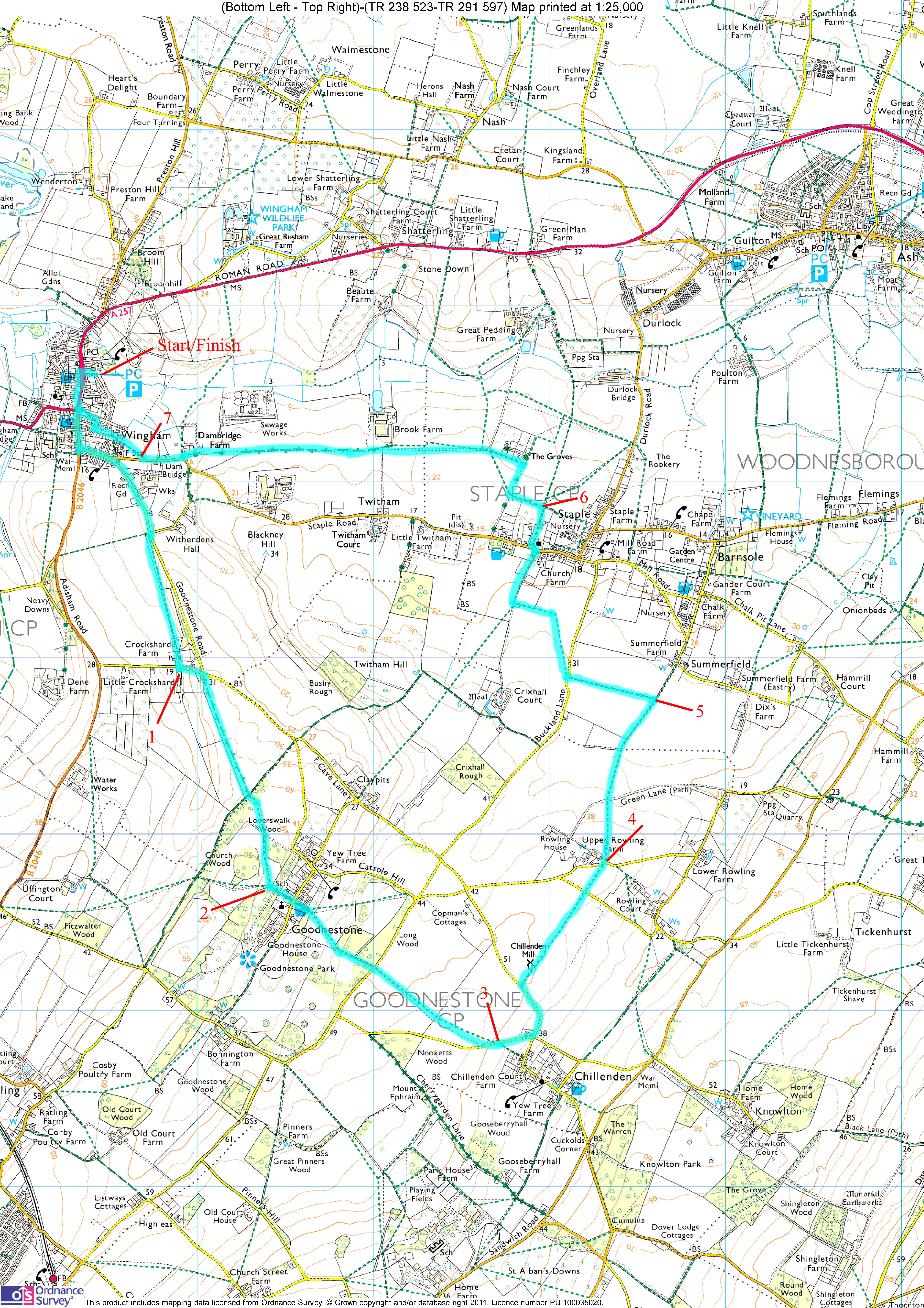
Click here to get an OS map with the route highlighted.
Click here to get a GPX file to load into your GPS gadget. (Right click, then Save As).
|
|