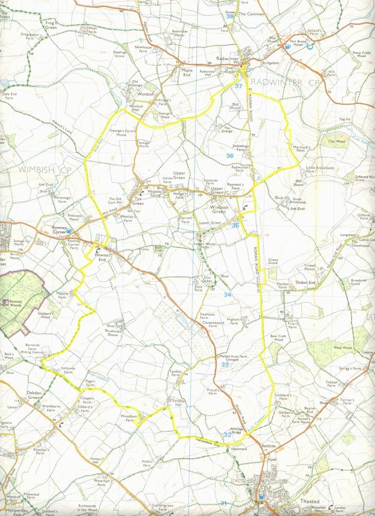
A circular walk from Radwinter going through the outskirts of Thaxted
Description: A pleasant walk in Essex with ever changing views. In formulating this walk, I've found there are sometimes some problem areas. I think I've ironed most of these out. With this in mind, the ideal time of year for this walk is when the crops on the fields are not too mature (before mid June.) Another good time also, is after harvest time (late August/early September,) else there may be some overgrown parts which could detract from the walk's enjoyment!
OS Ref: TL607373
Length: 11 Miles approx.
Approximate time: 4½-5 hours.
Parking: Roadside parking in Radwinter, near Church.
Refreshments: None during walk unless you venture into Thaxted.
The walk:
Start by heading along the road leading south from Radwinter. This is a former Roman road, and is marked as such on the OS map. After nearly 400 metres, turn left onto a footpath heading east across the middle of a field. Keep ahead, though a gap eventually turning right at the first waymarker you come to. Follow the left edge of the field, going through a gap, and climbing the gentle incline of the next field. Cross a stile at the far side of the field, then turn left and shortly afterwards right to follow the boundaries of a field to Mortlocks farm. This route isn't quite the same as the footpath marked on the OS map. I guess it's been changed slightly since the map was published. The last publication of the OS explorer number 195 was in 1998 at the time of writing. A long time ago relatively. I think they must be waiting to see how Stansted airport pans out for the next revision?
Anyway, continue past the farmhouse to follow a track. When you come to a lane, turn right into it, in a WSW direction. Just after the junction with a main road (coming from the right,) turn left onto a footpath. This follows the course of the Roman road we were on earlier. Follow this footpath, diving right after about 300 metres at a waymark post and across a bridge. Go across the middle of a field until you come to a road. Turn left then shortly afterwards follow a footpath signpost in the same direction. Keep ahead for 250 metres, then follow the footpath/lane left. After another 150 metres or so, turn right at a waymarker. The footpath here is sometimes really overgrown, but it has been ok the last few times I've been on it. Follow this footpath to eventually come out onto the right edge of a field. Continue in the same direction, going through a gap into another field. The map shows the path being directly across this field, but when it's full of the years crop, it is easier to turn left then follow the field boundary, coming out at the same point that the path follows across it. From hereon for a while, the paths are normally well defined when they have crops on them.
Go straight on in the same southerly direction, following the left side of two fields on a decent path. Cross a lane, going slightly left to follow the left edge of another field. Cross a footbridge then a stile to enter a conifer tree plantation. Follow the left edge of the plantation then cross another stile. Carry on for a while, turning left soon to follow a SSE direction.
Follow the right edge of two fields in this direction, going under a power line in the first. Turn right at the far corner of the second then cross a path. On the following field, take a southerly direction to walk diagonally across it. Start the field after this in the same direction, but divert slightly right half way across it to walk in a south-west direction where two paths cross. The paths are normally well defined here, so this isn't quite as complicated as it all sounds! Eventually, you will end up coming out onto the main Thaxted to Saffron Walden road. If you want to, you could turn left to explore Thaxted and its gorgeous Cathedral-like 15th century Church and picturesque Guildhall and their surroundings, including a windmill built in 1804.
If you have taken the detour into Thaxted, you'll have to get back to the point you left the walk route, which is just beyond a small bridge over the river Chelmer. Turn left just after this If you didn't take the detour, it's a small dog-leg right-left over the main road, crossing the bridge in the process.
Follow the left edge of a field. Go into the next field, then part of the way along, look for a gap through the hedge near its corner, to walk to the right edge of a field after crossing their boundary. You are now on the Harcamlow Way, and for the next two miles of the walk you will be following this route. The Harcamlow Way is a figure of eight path, starting and finishing in Harlow, Essex, with its midpoint in Newport, Essex. Its most northerly point is in Cambridge. Why is it called the Harcamlow Way? Well; it's the beginning and end of the word Harlow, with Cam(bridge) in the middle!
Anyway, sorry to digress with a pretty obvious point! Follow the right edge of the field you are now in, eventually coming to a point where the path is lined with trees. Go though these trees and just before the end of them, turn right to follow the Harcamlow Way. This turn is not always obvious, so you may have to look out for it!
Walk across the middle of a field in a NNW direction, follow the left edge of the next field (a young plantation) to come to a track. Turn left along this track and carry on to Woodham's farm. From hereon, the OS map route is a bit different to the present route for a while! The OS map shows the path going to the east of the farm, but carry on until you see a waymarker pointing right. Take this turn and follow the right edge of a field, first going right, then left to pick up where the original path went. Essentially, you have been following the boundary of what I can only describe as a storage yard for farm machinery.
Follow the left edge of field you are now on. Go under an electricity transmission line (the same one you went under earlier,) then shortly afterwards, cross a bridge into another field. Walk across this field to the opposite side, turn left, then follow its right edge until you come to a gap on the right. Turn right then follow the lane ahead. This gap is not always obvious, and you can actually miss it at some times during the year! Don't worry, if you do, shortly after it, look out for a road to the right, then turn right onto it, then turn left where the footpath sign points right (where you should have come out!)
Follow the lane, passing some buildings of Fellowes farm on the right. Shortly afterwards, take a byway, leaving the Harcamlow Way, which bears slightly right. This part can seem a bit ambiguous, but follow what seems to be the main route. You'll soon know if you're on the wrong track, because Rowney Woods will loom up fast!
Anyway, follow the byway. The next 2/3 mile can be a bit muddy, so you may have to tiptoe to the sides at times. The byway eventually gives way to Pepples Lane. Follow Pepples Lane, first to the right, then the left. Look out for a footpath sign on the right. Take this path, following the left edge of a field. Turn left at a waymarker, then turn right at another, cross a plank bridge then follow the path to come to the B184.
Turn right onto the B184, then after about 150 metres, turn left at a footpath sign just after a phone box. Follow this between houses, bearing left after a while at a meeting of paths, to eventually come to a road. Cross the road and follow a bridleway slightly to the right.
Walk down a gentle slope to the bottom. Cross a bridge (unless you want to wade across the river Pant on the horses route!) Turn right when you come to a clearing, and follow the bridleway in this direction (NNW) for a while, with the Pant to your right. At a waymarker, go through a gap to the right and continue in the same direction for 2/3 mile. When you get to the outskirts of Wimbish, at a tee junction, bear right to cross the Pant again. Follow a path with the river now to your left.
At a road, cross it going slightly right then left to follow a footpath. Walk along the left edge of the next three fields, with the river still to your left. In the last field, continue in the same direction, thus leaving the river for a while.
At a waymarker post, go through a gap into the corner of a meadow. Follow the right edge of this meadow, and at its end, turn left to cross a bridge then turn right. After a while, the path becomes enclosed, with a fence on the left.
Keep ahead on this path to come to a grassy area. Follow the path diagonally in the same direction to arrive at Radwinter Church. Go through a gap and continue along the path, now with a brick wall to the right. At the end, you have arrived back at the point the walk started, on part of a Roman road!
Click here to get an OS map with the route highlighted.
Click here for some photos taken along the route.
|
|